![]()
 |
 |
 |
 |
 |
 |
"THANK YOU" TO OUR INCREDIBLE PARTNERS! THEY ARE LISTED BELOW BY THEIR SAMPLE SITE(S)! Please check out our three videos to share the experience, and use the accompanying worksheets! |
||
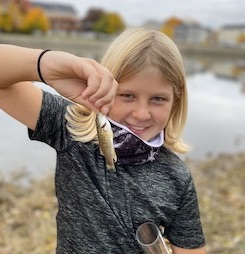
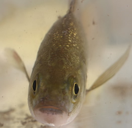
2020 was a year when COVID 19 kept most students from being part of our annal field sampling. Although our 18th year of the event looked a bit different, our incredible partner teams made the annual event not only possible, but pretty incredible! We want to thank all 48 sampling partners who together visited 56 sites to sample, film and share their time and incredbile talents with all the students! Last year we hosted ~5300 samplers in the field, this year 380 samplers were in the field, which over the course of the project brings our connectivity to 56,380 participants directly, however several of our groups hosted virtual events as they sampled linking several thousand students directly to the sampling! With this years total fish catch we have netted over 36,600 fish representing 80 different species in the watershed! Be sure to check out our 2020 salinity and fish worksheets located on the Activity Page! We hope that you all have a chance to spend time in the estuary through the coming year! |
||
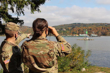
| For 2020 we developed three videosof the different parts of the estuary. Each is designed so students can visit the sites and collect data as they go. You are encouraged to focus on one section or to explore all three and use the different linked worksheets to travel through the video, and then use your data to answer a few questions at the end of the datasheet. Forquestions of additional information contact Margie Turrin at LDEO, Rebecca Houser or Chris Bowser with The Hudson River Estuary Program. | ||
 |
 |
 |
|
2020 FISH & SALINITY WORKSHEETS TEACHER VERSIONS PDF
|
|
|
Site Names/Locations & Partner |
Site Data | Site Names/Locations |
Site Data (pdf) |
|---|---|---|---|---|
| Files by Parameter | Adirondacks - Hudson Basin River Watch - RMs 310-317.5 | Croton Point Park - Teatown Lake Reservation & Westchester County Dept. of Parks, Recreation & Conservation | ||
Schoharie Creek - Middleburgh Jr/Sr School |
Mohawk RM53
|
Louis Engel Park, Ossining - Ossining High School | RM 32.5
|
|
| Tabbed Masterfile of all items below (xls) | Peebles Island - DEC Hudson River Estuary Program |
RM 154
|
Lower Nyack Beach, Nyack - Lamont-Doherty Earth Observatory, | RM 30.4
|
| Green Island - DEC Hudson River Estuary Program | RM 153
|
Nyack Memorial Park - Rockland County: Soil & Water Conservation District, & Conservation & Service Corps, Outoor Science Alliance |
RM 28
|
|
| Below: Parameter files by pdf | Corning Preserve, Albany - The College of St. Rose | Piermont Pier, Piermont - Lamont-Doherty Earth Observatory, & New York State DEC Hudson River Estuary Program | RM 25.4
|
|
| Site List | Schodack Island - River Haggie Outdoors & Resilience Communication & Consulting LLC | RM 134.5
|
Matthiessen Park, Irvington - Lamont-Doherty Earth Observatory, Philip Levine | RM 25
|
| Physical Factors | Nutten Hook Unique Area - River Haggie Outdoors & Resilience Communication & Consulting LLC | Beczak,Habirshaw Park, Yonkers - Sarah Lawrence College Center for the Urban River at Beczak | RM 18.3
|
|
| Turbidity | Lasher Memorial Park, Germantown - Columbia Land Conservancy |
Englewood Boat Basin, NJ - Meadowlands Environmental Center | RM 14
|
|
| Tides | Ulster Landing Park, Saugerties, impactEDUCATION | Inwood Hill Park, Hudson River -New York City Parks, Urban Park Rangers | RM 12.75
|
|
| Currents | Kingston Point, Kingston - Kingston Parks and Recreation | Hudson River Park Pier 84 - Hudson River Park & The Intrepid Sea, Air & Space Museum | RM 5.6
|
|
| Salinity (Partner Samples) | George Freer Park, Port Ewen - High Meadows School | Hudson River Park ~Pier 45 - New York City Soil & Water District | RM 3.2
|
|
Salinity Standardized /collected water samples |
Esopus Meadows, Ulster Park - Hudson River Sloop Clearwater | Hudson River Park Pier 40 - Hudson River Park | RM 2.9
|
|
Chemistry - D.O. & pH (also Nit/Phos/Alk) |
Norrie Point, Staatsburgh, New York State DEC Hudson River Estuary Program, & Kingston YMCA Farm Project | RM 84.5
|
Morris Canal Basin, New Jersey - Hudson Montessori School | RM 0.5
|
| Quiet Cove, Poughkeepsie - Cornell Cooperative Extension Dutchess County & No Child Left Inside | RM 78
|
Randall's & Ward's Island - Randall's Island Park Alliance | HrlRM 1
|
|
| Macroinvertebrate Catch | Wayras Park, Poughkeepsie - impactEDUCATION | RM 75.5
|
Concrete Plant, Bronx River - Bronx River Alliance | BrnxRM 4.5
|
| Long Dock, Beacon - Scenic Hudson | Hunts Point, Bronx River - Rocking the Boat |
BrnxRM 4
|
||
| People's Waterfront & Boat Launch, Newburgh - Scenic Hudson | John Finley Walk - Manhattan International High School | ER RM6
|
- ||
| Dennings Point, Beacon - Clarkson University's Beacon Institute for Rivers & Estuaries | Gantry Plaza Pier 1, East River - New York State Parks, Recreation & Historic Preservation |
ER RM5.7
|
||
| Kowawese, New Windsor - Orange County Water Authority | RM 58
|
Gantry Pier 4/Hunters Point, East River - New York City Department of Environmental Protection | ER RM5.6
|
|
| Cornwall Landing - New York State DEC Hudson River Estuary Program & New York State Parks, Bear Mountain Zoo | RM 57
|
Newtown Nature Walk - Billion Oyster Program | ER RM5.1
|
|
| Little Stony Point - New York State DEC Hudson River Estuary Program | RM 55
|
Bushwick Inlet Park - Billion Oyster Project | ER RM4.4
|
|
| West Point, South of Gee's Point - US Military Academy, West Point | Brooklyn Bridge Park East-East River, Brooklyn Bridge Park Conservancy | ER RM1.7
|
||
| Garrison Landing, Garrison - Katie Krueger Hirt | Governor's Island, Manhattan - The Harbor School | NYH -1
|
||
| Riverfront Green, Peekskill -DEC Hudson River Estuary Program | Pier 1 Lighthouse Museum, Staten Island - Curtis High School | NYH -4.5
|
||
| Verplanck, Steamboat Dock - DEC Hudson River Estuary Program | Canarsie Pier- New York State DEC | NYH -5.3
|
||
| Haverstraw Bay County Park- Rockland County: Soil & Water Conservation District, & Conservation & Service Corps | RM 38
|
Fort Wadsworth, Staten Island - St. Clare School & National Parks Service | NYH -7.5
|
|
| Fresh Kills Park, Staten Island - Freshkills Park Alliance | NYH -9
|