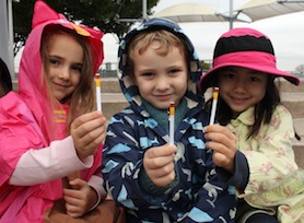
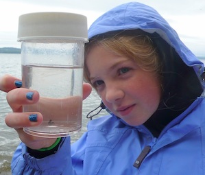
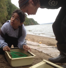
On our eleventh annual 'Day in the Life of the Hudson River 2013' the weather threated rain following a fairly dry August, that for the second straight year saw salt move up beyond Newburgh. The day was cold,
averaging a full 10 degrees Celcius colder than 2012 and in many areas the tides were at the high end of their range, challenging the seining teams. Overall fish counts were down, with several sites coming up with empty nets. Student observations from Hastings HS noted that "The tides and weather could affect the amount of fish in the area" and they saw the effects with no fish finding their way into the net during their seines. In the lower salty estuary large numbers of ctenaphores were reported while a pipefish turned up in the net in the freshwater site of Esopus Meadows. While 2012 had marked the end of regular monitoring by the USGS for the 'salt front' (recorded as 100 ppm Cl-) 2013 saw its return with the saltfront reported on 10/10/13 at RM 69.3 by New Hamburg.
Reflections, photos, poems, imaginings from the Day in the Life event 2013 |
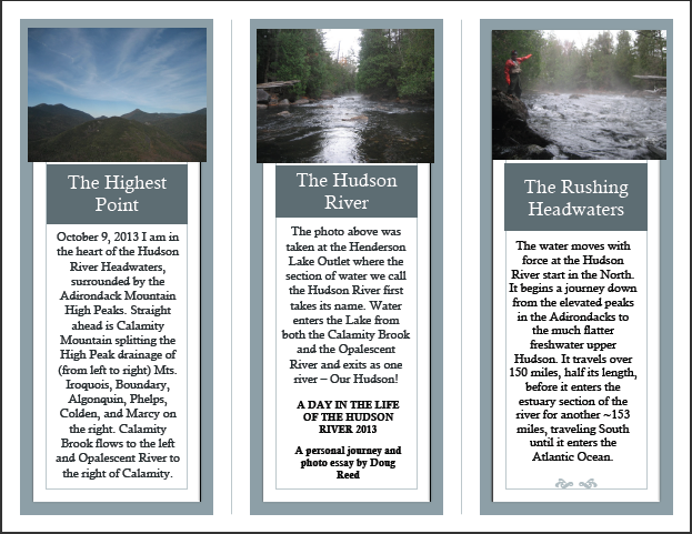 |
The full cycle of our Day in the Life of the Hudson River does not just start 10/10/13 at each of our sites. It begins at an given point in the Hudson River watershed days, weeks, months before our field event, when water starts to move through the watershed on its way to the Atlantic Ocean via the Hudson River. See this photo essay from Doug Reed, our most northern educator who started his Day in the Life journey on October 9th, 2013 high in the Adirondacks High Peaks looking at Mount Marcy which many of you will recognize as the northernmost start of the Hudson River. His site data is listed under RM 300. Many students reported being cold during sampling, but be sure to check the temperature data Doug collected! |
'Haibuns on the Hudson River ' |
On October 10th I took my class to visit the Saugerties Lighthouse. Lighthouse keeper, Patrick Landewe was kind enough to give us a tour —up into the observation tower!...more |
Reading & Writing the Hudson, Susan Fox Rogers & Bard College |
'Human Impact on the Hudson'
|
Humans are polluting the Hudson river everyday. Pipes of liquid waste, chemicals from our lawns, salt from our roads, boats, even ir pollution have an impact on our river. The water is precious, and what do we do? ...more |
Brian 7th grade Robert C. Parker School, Site: RM 153, Green Island, NY |
'Reflection on the Day' |
It was a grey day on the Hudson River. As we traveled into the brackish water, less and less fish and varieties of fish were found. Puzzling, very puzzling. It drizzled softly and as the fog grew, so did the waves as we drew nearer to the salty Atlantic. We could taste the salt in the air, we were close. |
Brian C. & Ian J. 6th grade North Colonie CSD, Site: RM 152, Watervleit, NY |
|
|
Site Names/Locations |
Files by Site (word) |
Files by Site (pdf) |
Site Names/Locations |
Site Data (word) |
Site Data (pdf) |
| *Grey designates a HS partner site |
Files by Topic |
Middleburgh Schoharie Creek |
Mowahk |
Mohawk |
Riverfront Green, Peekskill |
RM43 |
RM43 |
Sites & Participating Groups |
Newcomb, Adirondacks High Peaks |
RM300 |
RM300 |
Verplanck, Steamboat Dock |
RM41 |
RM41 |
| |
Hudson Crossing Park, Schuylerville |
RM200 |
RM200 |
George's Island |
RM 39.5 |
RM 39.5 |
| Tabbed Masterfile of all items listed below (excel format) |
Peebles Island -AM |
RM154 |
RM154 |
Croton Point Park, Croton-on-Hudson, MS |
RM35E |
RM35E |
BELOW: PDF FILES BY PARAMETER |
Green Island Park, Green Island |
RM153 |
RM153 |
Croton Point Park, HS |
RM35E |
RM35E |
| |
Watervleit |
RM152 |
RM152 |
Bowline Park, Haverstraw |
RM35W |
RM35W |
| Physical Factors |
Corning Preserve, Albany |
RM145 |
RM145 |
Louis Engel Waterfront Park, Ossining |
RM32 |
RM32 |
| Tides |
Rensselaer Riverfront Park |
RM144 |
RM144 |
Nyack Beach, Hook Mountain - Blue Rock |
RM31 |
RM31 |
Currents |
Henry Hudson Park, Bethlehem |
RM138 |
RM138 |
Kingsland Point Park, Sleepy Hollow |
RM30.5E |
RM30.5E |
| Salinity (student reported) |
Schodack Island State Park, Schodack Landing |
RM133 |
RM133 |
Nyack Memorial Park - HS |
HS RM28 |
HS RM28 |
| Salinity Standardized reading |
Stuyvesant Landing, Stuyvesant |
RM127 |
RM127 |
Nyack Memorial Park - UNES |
ES RM28 |
ES RM28 |
| Chemistry (DO/pH/Nit/Phos/Alk) |
Hudson Waterfront Park, Hudson |
RM118 |
RM118 |
Mathiessen Park, Irvington - HS |
HS RM25E |
HS RM25E |
Fish Catch |
Cohotate Preserve, Athens |
RM115 |
RM115 |
Mathiessen Park, Irvington - MS |
MS RM25E |
MS RM25E |
| Macroinvertebrate Catch |
Lasher Memorial Park, Germantown |
RM108 |
RM108 |
Piermont Pier |
RM25W |
RM25W |
| Shipping |
Saugerties Lighthouse, Saugerties |
RM102 |
RM102 |
MacEachron Waterfront Park, Hastings |
RM23 |
RM23 |
| Other Observations |
Ulster Landing Park, Saugerties |
RM97 |
RM97 |
Alpine Boat Basin |
RM18.5 |
RM18.5 |
| Chlorophyll Webpage |
Kingston Point, Kingston |
RM92 |
RM92 |
Beczak, Habirshaw Park, Yonkers |
RM18 |
RM18 |
| Sediment webpage |
George Freer Park, Port Ewen |
RM90 |
RM90 |
Mt. St. Vincent College, NYC-received no data |
RM 17 |
RM 17 |
|
Esopus Meadows, Ulster Park AM |
RM87 |
RM87 |
Inwood Hill Park, Harlem River - |
Harlem RM14 |
Harlem RM14 |
| Esopus Meadows, Ulster Park PM |
RM87 |
RM87 |
Sherman Creek Harlem River |
Harlem RM13b |
Harlem RM13b |
| Mills Mansion |
RM 85 |
RM 85 |
Swindler Cove Harlem River |
Harlem RM13a |
Harlem RM13a |
| Norrie Point, Staatsburgh |
RM84.5 |
RM84.5 |
Fort Washington Park |
RM11.5 |
RM11.5 |
| Quiet Cove, Poughkeepsie |
RM78 |
RM78 |
59th Street - Riverside Park |
RM 5 |
RM 5 |
| Waryas Park, Poughkeepsie |
RM76E |
RM76E |
Hudson River Park's Pier 84 - AM |
RM4 |
RM4 |
| Bob Shepard Highland Landing Park, Highland |
RM76W |
RM76W |
Hudson River Park's Pier 84 - PM |
RM4 |
RM4 |
Riverfront Park, Beacon |
RM61.1 |
RM61.1 |
Hudson River Park's Pier 45 - NYCSWD |
RM2.5 |
RM2.5 |
| Long Dock, Beacon |
RM61E |
RM61E |
Hudson River Park's Pier 45 - Wallerstein |
RM2.5 |
RM2.5 |
| Newburgh Landing, Newburgh |
RM61W |
RM61W |
Hudson River Park Pier 40, River Project |
RM2 |
RM2 |
| Dennings Point, Beacon |
RM60 |
RM60 |
Brooklyn Bridge Conservancy, East River |
East River RM1E |
East River RM1E |
| Kowawese Unique Area |
RM58a |
RM58a |
Lower East Side Ecology Center, East River |
East River RM1W |
East River RM1W |
| Kowawese New Windsor |
RM58b |
RM58b |
Upper NY Bay/ Buttermilk Channel |
Governor's Island |
Governor's Island |
| Donahue Memorial Park, Cornwall Landing |
RM57 |
RM57 |
Gerritsen Creek |
Jamaica Bay |
Jamaica Bay |
| Little Stony Point, Cold Spring |
RM55 |
RM55 |
South of Fort Wadsworth, Verrazano Bridge |
RM-7 |
RM-7 |