![]()
 |
 |
|
 |
 |
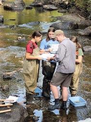 |
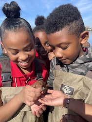
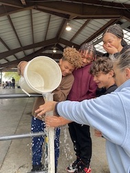
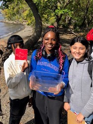
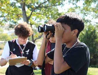
For "Day in the Life of the Hudson and Harbor 2023" the watershed was filled with samplers from its furthest reaches north to the Adirondacks, west to the Mohawk, east to the Hoosick and south to the lower mouth of the Harbor! Student groups were supported by research scientists, environmental educators, partner organizations, Student Conservation Association members, DEC fisheries teams and DEC staff throughout the region as everyone worked together to collect data from their own unique site. As has become tradition, many of our upriver sites were visited by members of the DEC fisheries teams who brought catches of mature fish for students to identify and enjoy. This year close to 4200 students and ~ 725 adults sampled at 90 sites along the river. Over the past 20 years we have worked with ~68,766 students, teachers and environmental educators measuring salinity, chemistry, turbidity, biology and sediments. This year our current fish count is 3610 fish were netted from 50 different species across 61sites. Over the twenty years of this event we have netted 46,862 fish from 92 different species have been netted, representing close to 40% of the 237 species documented in the Hudson River watershed! To see a sumary of our findings see the 2023 worksheets linked below. |
||
WORKSHEETS FROM 2023 DAY IN THE LIFE RESULTS |
||
Student 2023 Worksheets |
Teacher 2023 Worksheets |
 - Joan Christou copy.jpg) Sampling Background: October 5th was a beautiful warm, clear day throughout the Hudson Valley and the wider watershed. However, leading up to the event, the summer and early fall had been wet throughout much of the Hudson Valley, with regular rain moving freshwater into the Hudson from its many tributaries, leading us to predict that on 10/5/23 the salt fron in the Hudson (measured @100 ppm chloride or 181 ppm total salinity) would be much lower than last year's location (Poughkeepsie ~RM76). Water samples collected during the event showed the leading edge of salt was ~25 miles further south at West Point area ~RM52! And this is connected to the fish! Check our worksheets for more on this. For the first time in 2023 samplers in the middle Hudson sites (Westchester & Rockland) cited a noticable presence of the invasive spotted lanternfly (Lycoma delicatula) at their sampling locations.
Sampling Background: October 5th was a beautiful warm, clear day throughout the Hudson Valley and the wider watershed. However, leading up to the event, the summer and early fall had been wet throughout much of the Hudson Valley, with regular rain moving freshwater into the Hudson from its many tributaries, leading us to predict that on 10/5/23 the salt fron in the Hudson (measured @100 ppm chloride or 181 ppm total salinity) would be much lower than last year's location (Poughkeepsie ~RM76). Water samples collected during the event showed the leading edge of salt was ~25 miles further south at West Point area ~RM52! And this is connected to the fish! Check our worksheets for more on this. For the first time in 2023 samplers in the middle Hudson sites (Westchester & Rockland) cited a noticable presence of the invasive spotted lanternfly (Lycoma delicatula) at their sampling locations.*Grey designates a HS or undergrad partner site
Site Names/Locations
Site Names/Locations
Nyack Memorial Park Liberty ES
Sites & Participating Groups
Schoharie Creek, Northvale Central HS
Rensselaer Boat Launch, TVHS
Inwood Hill Park, Hudson River
The Baylander @ 125th St.
Pier 103rd St. & Hudson River, Manhattan
Gantry Plaza Pier 1, East River
Gantry Pier 4/Hunters Point, East River
Brooklyn Bridge Park East-Peeble Beach, Pier1
Valentino Pier, Red Hook
Nyack Memorial Park NYHS