![]()
 |
 |
 |
 |
 |
 |
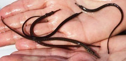 |
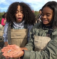
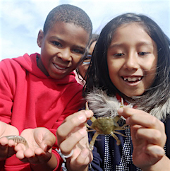
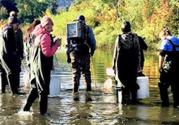
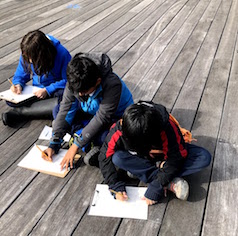
In 2018 we celebrated our 16th year by expanding our name to 'Day in the Life of the Hudson and Harbor' to recognize the wide group of samplers from the lower estuary. Through the years we have worked with over 50,000 students, teachers and environmental educators studying the river at more than 100 riverfront sites, measuring salinity, chemistry, turbidity, biology and sediments. Over 30,000 fish from 79 different species, representing one third of the 228 species documented to data in the Hudson River watershed have been netted! What a whirlwind of learning! To the left is a photo of northern pipefish from salty Ferry Point Park, the most slender fish in the estuary. Above are students working with fisheries staff sampling larger fish in a Hudson tributary. |
|
*Grey designates a HS or undergrad partner site |
Site Names/Locations |
Site Data (word or xls) | Site Data (pdf) | Site Names/Locations |
Site Data (word or xls) | Site Data (pdf) |
|---|---|---|---|---|---|---|
| Files by Parameter | Hoosick River, Hoosick Falls High School | Hoosick | Hoosick | Nyack Memorial Park AM Liberty ES |
||
Schoharie Creek, Middleburgh HS |
Mohawk Drainage | Mohawk Drainage | Nyack Memorial Park PM UNES |
|||
| Tabbed Masterfile of all items below (xls) | Niskayuna Lock 7, River Run Community | Mohawk River | Piermont Pier, Piermont | RM25.s4 | RM25.4 | |
| Below: Parameter files by pdf | Hudson Crossing Park |
RM200 | RM200 | Matthiessen Park, Irvington | RM25 (xls) | RM25 |
| Physical Factors | Peebles Island - HS |
RM154 | RM154 | Dobbs Ferry | RM23 | RM23 |
| Turbidity | Peebles Island - ES | RM154 | RM154 | MacEachron Park, Hastings | RM22 | RM22 |
| Tides | Green Island Park, Green Island | JFK Marina, Yonkers | RM19.5 | RM19.5 | ||
| Hudson Shores Park, Watervleit | RM152 | RM152 | Alpine Boat Basin, Alpine NJ (Alpine) | RM19 | RM19 | |
| Salinity (student reported) | Rensselaer Boat Launch, TVHS & Delaware School (AM) |
RM146 | RM146 | Beczak,Habirshaw Park, Yonkers | RM18.3 | RM18.3 |
| Corning Preserve, Albany | RM145.5 | RM145.5 | Inwood Hill Park, Harlem River (Kingsbridge Acad) | Hrl RM14 | Hrl RM14 | |
Chemistry - D.O. & pH (also Nit/Phos/Alk) |
Rensselaer Riverfront Park | RM144.5 | RM144.5 | Englewood Boat Basin, NJ | RM13 | RM13 |
| Papscanee Preserve | RM140 | RM140 | Englewood Boat Basin, NJ, PascackHS | RM13 (xls) | RM13 | |
| Macroinvertebrate Catch | Henry Hudson Park, Bethlehem | RM138 | RM138 | Fort Washington Park | RM11.5 | RM11.5 |
| Schodack Island | RM133.4 | RM133.4 | Pier 125th St., NYC (HSMSE) | RM10 | RM10 | |
| Nutten Hook Unique Area | RM 124.5 | RM 124.5 | Pier 125th St., NYC, Columbia Secondary |
RM10 | RM10 | |
| Riverfront Park, Coxsackie | RM123 | Pier 125th St., NYC, Boat Sampling | RM10 | RM10 | ||
Athen Riverside Park, Athens |
79th St. Boat Basin, Clearwater | RM7.3 | RM7.3 | |||
| Hudson Waterfront Park, Hudson | RM117 | RM117 | Pier i, 59th Street - Riverside Park | RM6.8 | RM6.8 | |
| Cohotate Preserve, Athens | RM115 | RM115 | Hudson River Park Pier 84 AM | RM5.6 | RM5.6 | |
| Lasher Memorial Park, Germantown | RM108.5 | RM108.5 | Hudson River Park Pier 45 (NYSWD) | RM3.2 | RM3.2 | |
| Saugerties Lighthouse, Saugerties | RM102 (xls) | RM102 | Hudson River Park Pier 45 - (Lab HS) | RM3.2 LHS | ||
| Falling Water, Glasco, Ulster | RM100.5 | RM100.5 | Hudson River Park Pier 45 - (NYU) | RM3.2 CHS | RM3.2CHS | |
| Tivoli Bay South, Redhook | RM98 | Hudson River Park Pier 45 - (NYU) | ||||
| Ulster Landing Park, Saugerties | Hudson River Park Pier 40 | RM2.9 | RM2.9 | |||
| Kingston Point, Kingston | RM92 | RM92 | Morris Canal Basin, New Jersey | RM0.5 | RM0.5 | |
| Esopus Meadows, Ulster Park | RM87 | Randall's & Ward's Island | HrlRM1 | HrlRM1 | ||
| Norrie Point, Staatsburgh | Concrete Plant, Bronx River (Pelham HS) | BrxRM4.5 | BrxRM4.5 | |||
| Quiet Cove, Poughkeepsie | RM78 | RM78 | Concrete Plant, Bronx River (Bronx HS) | BrxRM4.5 | BrxRM4.5 | |
| Marist Waterfront, Marist College | RM 76.5 | RM 76.5 | Hunts Point, Bronx River |
BrxRM4 | BrxRM4 | |
| Waryas Park/Fallkill Poughkeepsie | RM76 | RM76 | Little Bay, Fort Totten Park, East River | ER RM15.2 | ER RM15.2 | |
| Chelsea Boat Launch, Wappinger Falls | RM65 | RM65 | Ferry Point Park, East River (KIPP) | ER RM13.5 AM | ER RM13.5 AM | |
| Riverfront Park, Beacon | RM61.2 | RM61.2 | Ferry Point Park, East River (West Bronx) | ER RM13.5 AM | ER RM13.5 AM | |
| Long Dock, Beacon | RM61 | RM61 | Ferry Point Park, East River (Renaissance) | ER RM13.5 AM | ER RM13.5 AM | |
| People's Waterfront & Boat Launch, Newburgh | RM60.5 | RM60.5 | Gantry Plaza, East River |
ER RM5.7 | ER RM5.7 | |
| Dennings Point, Beacon | RM60 (xls) | RM60 | Hunters Point, East River (MS) newsletter | ER RM5.6 (xls) | ER RM5.6 | |
| Plum Point, New Windsor | RM58.1 | RM58.1 | Solar One, East River | ER RM4.9 | ER RM4.9 | |
| Cornwall Landing | RM57 | RM57 | Brooklyn Bridge West-East River - | ER RM2.3 AM | ER RM2.3 AM | |
| West Point, South of Gee's Point | RM52 | South Street Seaport | ER RM1.9 | ER RM1.9 | ||
| Garrison Landing, Garrison | RM51.5 | RM51.5 | Brooklyn Bridge Park East - East River | ER RM1.7 | ER RM1.7 | |
| Riverfront Green, Peekskill | RM43.5 | RM43.5 | Governor's Island, Manhattan | NYH-1 | ||
| Verplanck, Steamboat Dock | RM41 | Valentino Pier, Red Hook AM |
||||
| George's Island | RM40 | RM40 | Bush Terminal Park, Brooklyn | NYH-3.7 (xls) | NYH-3.7 | |
| Stony Point Seawall/ Point Marina | RM39 | RM39 | Pier 1 Lighthouse Museum, Staten Island | NYH-4.5 (xls) | NYH-4.5 | |
| Haverstraw Bay County Park | RM38 | Bay Ridge Veterans's Memorial Pier, Brooklyn | NYH-4.7 | NYH-4.7 | ||
Croton Point Park, Croton-on-Hudson |
Canarsie Pier 2 groups MS & HS - no data submitted | NYH-5.3 | NYH-5.3 | |||
| Louis Engel Park, Ossining | RM 32.5 | RM 32.5 | Dubo's Point, Rockaways | NYH-7.1 | NYH-7.1 | |
| Hook Mtn. State Park Steps, Clarkstown North HS | RM30.5 (xls) | RM30.5 | Fort Wadsworth, Staten Island | NYH -7.5 | NYH -7.5 | |
| Lower Nyack Beach, Nyack - Blue Rock | RM30.4 | RM30.4 | Kaiser Park, Brooklyn | NYH-8.6 (xls) | NYH-8.6 | |
Nyack Memorial Park |
Coney Island Pier, Brooklyn | NYH-9.1 | NYH-9.1 |